Less than 30 miles southwest of Las Vegas, a ±234-acre mixed-use development opportunity sits at the intersection of Nevada’s mining past and Clark County’s growth future. Potosi Mine Ranch, protected under 1872 Patented Mining Claims, combines what historical records describe as Southern Nevada’s oldest mine with 145 acre-feet of water rights, an approved tentative map for 104 residential lots, and a development timeline extending to 2027. For landlords and property investors considering Nevada land, this property illustrates how water rights, patented claims, and development entitlements converge to create layered value in the desert Southwest.
The Property
Potosi Mine Ranch spans ±234 acres across 15 parcels at 11951 Mount Potosi Canyon Rd, Las Vegas, NV 89161. The parcels consist of Patented Lode mining claims, mill sites, the Potosi Mine itself, and water rights designated for quasi-municipal use. The property is zoned RS80 (Residential Single-Family) and carries an approved tentative map for a maximum of 104 residential lots. A use permit for a 112-room health spa retreat and recreational facilities has been considered for the ±25-acre Mill Sites.
Per the Notice of Final Action dated August 28, 2023, the development start date has been extended to July 17, 2027. Current access is via a county-maintained dirt road suitable for trucks or 4×4 vehicles. Environmental and drainage studies are underway for a proposed 32-foot-wide paved road with a shoulder spanning approximately 7.83 miles to access the tentative map area. The nearest substation is Valley Electric – Sandy Valley at approximately 5.46 miles, with major transmission lines approximately 2.45 miles away.
An existing ±1,089-square-foot A-frame cabin built in 1998 sits on the property, serviced by well, septic, and Valley Electric. The property is listed by Jeremy A. Green, SIOR, of Kidder Mathews.
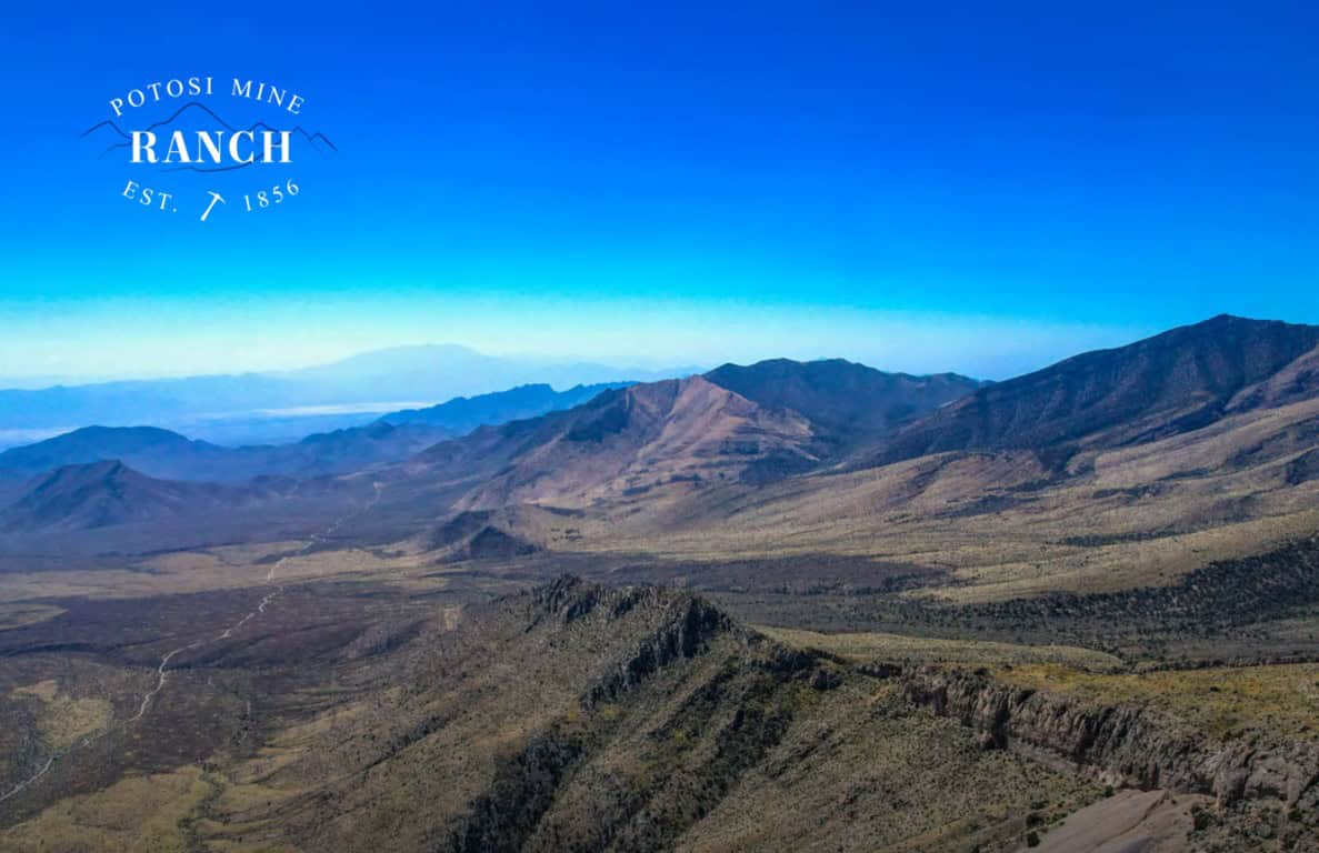
Location and Setting
Potosi Mine Ranch sits in Mount Potosi Canyon near the historic Old Spanish Trail, within the Spring Mountains National Recreation Area and the Humboldt-Toiyabe National Forest, the largest national forest outside Alaska at approximately 6.3 million acres. The property is less than 30 miles southwest of Las Vegas, with Harry Reid International Airport only 29 miles away, approximately 49 to 54 minutes by car. Drive times include approximately 23 minutes to Enterprise, 37 minutes to Pahrump, and 44 minutes to Las Vegas.
The Potosi Spring at the Base Mill site area has an elevation of ±5,685 feet, while the highest elevation at the Upper Lode sites reaches ±6,840 feet. The area receives average annual precipitation of 10.7 inches, with an average high temperature of 66.5°F and an average low of 44.5°F, significantly cooler than the Las Vegas Valley floor, where summer highs regularly exceed 100°F. Vegetation includes pinyon pine, juniper, cactus, flowers, and sagebrush. Petroglyphs, rock shelters, and mescal pits are also found in the area.
The property is surrounded by U.S. Forest Service land. The Spring Mountains National Recreation Area encompasses approximately 316,000 acres, drawing visitors to its multiple ecological zones and trails. Red Rock Canyon National Conservation Area lies approximately 15 to 20 miles north, attracting approximately 3 million visitors per year to its sandstone formations and scenic loop drive.
Potosi Mountain itself rises to 8,517 feet and houses a large cave with a unique history, over seven FM transmitters, and a NOAA All Hazards Radio station WNG634. According to the offering materials, KXTE was the first tenant to broadcast from the mountaintop and the first station in the United States to transmit in HD Signal.
Mining History: Southern Nevada’s Oldest Mine
According to historical records cited in the offering materials (Queho Posse Chapter 1919 E Clampus Vitus), “The Potosi Mine is the oldest in Southern Nevada.” The mine was originally located in April 1856 when a Paiute Indian showed Mormon miners where “heavy rock” could be found. The desire of local Mormon settlers for economic self-sufficiency led to mining by missionaries for lead at Potosí.
In 1857, Nathaniel V. Jones was sent to recover ore from the “mountain of lead” 30 miles southwest of the mission at Las Vegas Springs. About 9,000 pounds were recovered before smelting difficulties forced the remote mine to be abandoned in 1858. According to the historical record, Potosi became the first abandoned mine in Nevada.
In 1861, California mining interests reopened the mine. A smelter and rock cabins for 100 miners made up the camp of Potosi. Even more extensive operations followed after the transcontinental Salt Lake and San Pedro Railroad (now the Union Pacific) was built through the county in 1905. By October 1868, following Nevada’s admission to the Union as the 36th state during the Civil War, the Potosi Mine was already established as the first lode mine and abandoned town in Nevada.
Production and Critical Mineral Status
During World War I, Potosi was an important source of zinc, the second largest zinc production in the county. The mine was intermittently active since 1857 and produced commodities including zinc, lead, silver, copper, and gold. Historical production figures include more than 44,000 lbs zinc, 3 million lbs lead, 40,000 oz silver, 27,000 lbs copper, and 24 oz gold. The 200,000-ton mine dump remains on the property.
Zinc, one of Potosi’s primary minerals, is listed as a Critical Mineral, which may have value consideration in government recovery and supply chain efforts. The Potosi Mine was admitted to the National Register of Historic Places with reference to commerce and mining colonization in the 19th and 20th centuries. In 1968, the mine was also classified as a national fallout shelter for naval facilities Engineering Command. Air quality and safety reports are available from the Division of Mine Safety and Health qualifying the Potosi Mine for museum and mine tours.
Watch an exploration of the Potosi Mine: Rockhounding & Exploring Nevada’s Oldest Abandoned Mine (YouTube)
Water Rights: 145 Acre-Feet and Why They Matter
The property includes Nevada underground well permits 88245 and 88246, each designated at 0.11 CFS flow rate and 72.5 AFA, for a total of 145 acre-feet annually. The permits are designated for quasi-municipal use and were approved on October 20, 2023, with a priority date of July 22, 2021. Proof of completion (POC) and proof of beneficial use (PBU) are approved, with a due date of March 26, 2028. The property also includes surface water rights to the Potosi Artesian Spring, with studies available demonstrating flow rate and monitoring history.
To put this in context:
145 acre-feet equals approximately 47.25 million gallons per year, potentially supporting 250 to 300 homes depending on usage patterns. In the driest state in the nation, water rights of this scale represent a significant asset, particularly when attached to development entitlements.
Nevada administers water under the prior appropriation doctrine, “first in time, first in right”, through the Nevada Division of Water Resources under NRS Chapters 533 (surface water) and 534 (groundwater). Under this framework, senior water rights holders are satisfied fully before junior rights receive anything during shortages. The quasi-municipal (QM) designation allows serving multiple connections from a private well system, often allowing up to approximately 1,000 gallons per day per connection, subject to permit terms, more flexible than a single domestic well permit.
What makes these rights particularly strategic is their independence from the Colorado River system. Southern Nevada draws nearly all its municipal water from Lake Mead, which has been under shortage conditions since 2021, the first-ever shortage declaration on the Colorado River. Water rights tied to artesian spring sources in the Spring Mountains aquifer system, which may reduce or eliminate pumping requirements depending on pressure conditions, represent a fundamentally different source of supply.
In Southern Nevada, new water appropriations are extremely limited, with most supply coming from transfers of existing rights. Water rights in Clark County have historically been reported in the range of $10,000 to $25,000 per acre-foot, depending on seniority and use type, though this market is variable and transactions are relatively rare. By these benchmarks, the ranch’s 145 acre-feet represents an estimated value of $1.45 million to $3.6 million for the water rights alone.
The Carole Lombard Tragedy
On January 16, 1942, actress Carole Lombard, who was married to Clark Gable, passed away at age 33 in a plane crash. She was aboard TWA Flight 3, a Silver DC-3 Sky Club airliner, returning from a war bond tour during which she had raised $2 million for the World War II effort. The plane crashed on Potosi Mountain, killing 21 veterans and service members in addition to Lombard, 22 passengers in total.
According to the offering materials: “When Lombard’s husband, the renowned actor Clark Gable, lost his wife in a plane crash, he immediately rushed to the Pioneer Saloon, where the search party was headquartered. Gable spent three agonizing days at the saloon, waiting for news of any survivors.” Gable’s cigar burns still mark the bar counter, serving as a reminder of those three days.
Pioneer Saloon and the Town of Goodsprings
Pioneer Saloon, located in nearby Goodsprings, dates back to the early 1900s. Its walls are stamped tin, manufactured by Sears and Roebuck, believed to be one of the last of their kind in the United States. The bar is a solid wood Brunswick, made in Maine in the 1860s and moved to Goodsprings in 1913. The original US Army Cannon Heater stove still heats the building today, and dining tables have been in place since the saloon’s opening day.
1872 Patented Mining Claims: A Finite Asset Class
The 15 parcels comprising Potosi Mine Ranch are protected under 1872 Patented Mining Claims. Under the General Mining Law of 1872, U.S. citizens could stake claims on the federal public domain and, after demonstrating a valuable mineral discovery and completing required development work, receive a patent conveying full fee-simple ownership of both surface and mineral rights. Patented claims function identically to private land, with explicitly confirmed mineral rights that remain with the property.
In 1994, Congress imposed a moratorium on processing new mineral patent applications, which has been renewed annually since. This moratorium means existing patented mining claims are a finite asset class, no new ones will be created under current law. Between 1867 and 2001, the Department of the Interior issued approximately 65,000 mineral patents covering roughly 3.2 million acres nationwide. The Potosi Mine Ranch parcels represent private land within the Humboldt-Toiyabe National Forest, an increasingly uncommon “inholding” configuration providing both exclusivity and access to surrounding public lands.
Development Potential
The approved tentative map for 104 residential lots under RS80 zoning (minimum 80,000-square-foot lots, roughly 1.84 acres each) represents significant entitled value. In Clark County, tentative map approval means the Planning Commission has reviewed and conditionally approved the subdivision layout, a process that typically takes years. The NOFA-established development start date of July 17, 2027 provides a defined near-term window for development initiation.
Beyond residential subdivision, a use permit for a 112-room health spa retreat and recreational facilities has been considered for the five mill sites totaling ±25 acres. Under the 1872 Mining Law, mill sites are parcels of nonmineral land (maximum 5 acres each) originally used for ore processing. As patented land, these mill sites can be used for any legal purpose, making them suitable for commercial development. The combination of mountain setting, artesian spring water, historic mine features, and proximity to Las Vegas creates a compelling case for destination-oriented development.
Infrastructure requirements include the proposed 32-foot-wide paved road (approximately 7.83 miles from NV-160), electrical service from Valley Electric Association via the Sandy Valley substation, and wastewater solutions, likely individual septic systems or a package treatment plant approved by the Southern Nevada Health District. Environmental permitting has been underway, with the professional team working toward clearances as outlined in the offering materials.
Prospective buyers should note that historic mining properties carry specific due diligence requirements. Given the mine’s 170-year history of lead and zinc extraction, a Phase I Environmental Site Assessment would likely identify Recognized Environmental Conditions, and a Phase II assessment involving soil sampling, groundwater testing, and heavy metals analysis would typically follow. CERCLA liability applies to historic mining sites, making the bona fide prospective purchaser defense, which requires proper All Appropriate Inquiries, an essential consideration for any buyer.
Clark County: Why Location Matters
According to the Las Vegas Global Economic Alliance, cited directly in the offering materials, Clark County ranks among the top regions in the nation for growth and investment:
- #1 State for Job Growth in the U.S.
- #2 Fastest Growing Counties in the U.S.
- 3× the U.S. average in population growth
- #6 Ranked Millennial Magnet State
- #8 Top Ranked Overall Business Climate
- 10,000+ businesses created in the county since 2011
- 180,000+ jobs created in the county since 2011
Nevada’s tax climate is frequently cited as a driver of business and population growth. The state has no corporate income tax, no personal income tax, no inventory tax, no franchise tax on income, and no inheritance, pension, or Social Security tax. Property taxes remain low relative to national averages.
Clark County’s population has grown to approximately 2.4 million residents, adding on the order of 100 or more new residents per day in recent years. Growth has been driven by continued migration, particularly from higher-tax states, and major infrastructure investment. In a state where over 80% of land is federally owned, privately held acreage with water rights and development entitlements represents a notably scarce asset class.
Conclusion
Potosi Mine Ranch combines multiple value layers that rarely coexist in a single property: 145 acre-feet of water rights with quasi-municipal designation and a 2028 PBU deadline, 104-lot development entitlements with a July 2027 start date, 1872 patented mining claims representing a finite asset class, a Critical Mineral designation for zinc, National Register of Historic Places listing, and a location less than 30 miles from one of America’s fastest-growing metropolitan areas. For property investors evaluating Nevada land, the ranch illustrates a fundamental principle of desert Southwest real estate: the most durable value comes from properties that combine water, entitlements, mineral rights, and location rather than relying on any single attribute.
For more information on Potosi Mine Ranch, visit claimpmr.com or potosimineranch.com.
| Questions about property management in Las Vegas? IRES Vegas provides full-service property management for landlords throughout the Las Vegas Valley. Contact us at 702-478-2242 or visit iresvegas.com to learn how we can help maximize your investment returns. |